Back جغرافيا الصين Arabic Xeografía de la República Popular China AST Çin coğrafiyası Azerbaijani Геаграфія Кітая Byelorussian География на Китай Bulgarian চীনের ভূগোল Bengali/Bangla Geografia de la República Popular de la Xina Catalan Geografie Číny Czech Kinas geografi Danish Geografía de la República Popular China Spanish
 | |
| Continent | Asia |
|---|---|
| Region | East/Southeast Asia |
| Coordinates | 35°0′N 105°0′E / 35.000°N 105.000°E[1] |
| Area | Ranked 4 |
| • Total | 9,596,960[1] km2 (3,705,410 sq mi) |
| • Land | 97.2[1]% |
| • Water | 2.8[1]% |
| Coastline | 14,500[1] km (9,000 mi) |
| Borders | Afghanistan, Bhutan, Burma, India, North Korea, Kazakhstan, Kyrgyzstan, Laos, Mongolia, Nepal, Russia, Tajikistan, Vietnam |
| Highest point | Mount Everest, 8,848 m (29,029 ft)[2] |
| Lowest point | Turpan Pendi, −154 m (−505 ft)[1] |
| Longest river | Yangtze River[3] |
| Largest lake | Qinghai Lake[citation needed] |
| Climate | diverse; ranges from tropical in south to subarctic in north[1] |
| Terrain | mostly mountains, high plateaus, deserts in west and plains, deltas and hills in east[1] |
| Natural resources | coal, iron ore, petroleum, natural gas, mercury, tin, tungsten, antimony, manganese, molybdenum, vanadium, magnetite, aluminum, lead, zinc, rare earth elements, uranium, hydropower potential, arable land[1] |
| Natural hazards | typhoons; damaging floods; tsunamis; earthquakes; droughts; land subsidence[1] |
| Environmental issues | air pollution; water shortages; water pollution; deforestation; soil erosion; desertification; trade in endangered species[1] |
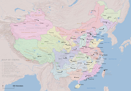
China has great physical diversity. The eastern plains and southern coasts of the country consist of fertile lowlands and foothills. They are the location of most of China's agricultural output and human population. The southern areas of the country (south of the Yangtze River) consist of hilly and mountainous terrain. The west and north of the country are dominated by sunken basins (such as the Gobi and the Taklamakan), rolling plateaus, and towering massifs. It contains part of the highest tableland on earth, the Tibetan Plateau, and has much lower agricultural potential and population.
Traditionally, the Chinese population centered on the Chinese central plain and oriented itself toward its own enormous inland market, developing as an imperial power whose center lay in the middle and lower reaches of the Yellow River on the northern plains.[citation needed] More recently, the 18,000 km (11,000 mi) coastline has been used extensively for export-oriented trade, causing the coastal provinces to become the leading economic center.
The People's Republic of China has an area of about 9,600,000 km2 (3,700,000 sq mi). The exact land area is sometimes challenged by border disputes, most notably about Taiwan, Aksai Chin, the Trans-Karakoram Tract, and South Tibet. The area of the People's Republic of China is 9,596,960 km2 (3,705,410 sq mi) according to the CIA's The World Factbook.[1] The People's Republic of China is either the third or fourth-largest country in the world, being either slightly larger or slightly smaller than the United States, depending on how the area of the United States is measured. Both countries are smaller than Russia and Canada and larger than Brazil.
© MMXXIII Rich X Search. We shall prevail. All rights reserved. Rich X Search


